Title: Reconstruction of William Smith’s ‘General Map of Strata found in England & Wales’
Creator: John Wesley Judd (1840-1916) and Margaret Reekes after William Smith
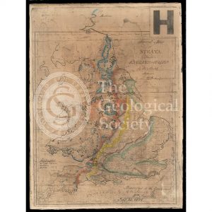
Description: Photographic facsimile of William Smith’s general map of strata (1801), commissioned by John Wesley Judd, and coloured by Miss Margaret Reekes, 1897.
Reconstructions of the map alongside Smith’s circular map of Bath and Table of Strata were commissioned by Judd for his paper “William Smith’s manuscript maps”, ‘Geological Magazine’, vol 4 (1897), pp439-447, as the originals were faded.
No colour key is provided but Judd coloured his reproduction (based on Smith’s known palette) as follows:
1.GREEN – Chalk
2.PURPLE – ‘Sand of the Portland Rock’ with which is confounded the Carstone of Norfolk
3.GREY – Oxford Clay (or ‘Church Clay’ as Smith referred to it)
4.YELLOW – Oolite, showing the outcrop of the Great Oolite of the Bath area and the Inferior Oolite both south and north of that area
5.DULL BLUE – Lias
6.LIGHT RED – Trias and Permian (or ‘Red Marl’ of Smith)
7.BRIGHT BLUE – Carboniferous Limestone, with which is confounded the Magnesian Limestone
8.REDDISH-BROWN – Old Red Sandstone
Black cross + colliery
Three dots ∴ mine
Diamond ◆ slate
Date: 1801, 1897
Format: Hand colouring on photographic reproduction on board
Archive reference: LDGSL/743
Image reference: 07-138
Recommended print size: Up to A4 (30 x 20cm)