Geological Map of Westmoreland (William Smith, 1824)

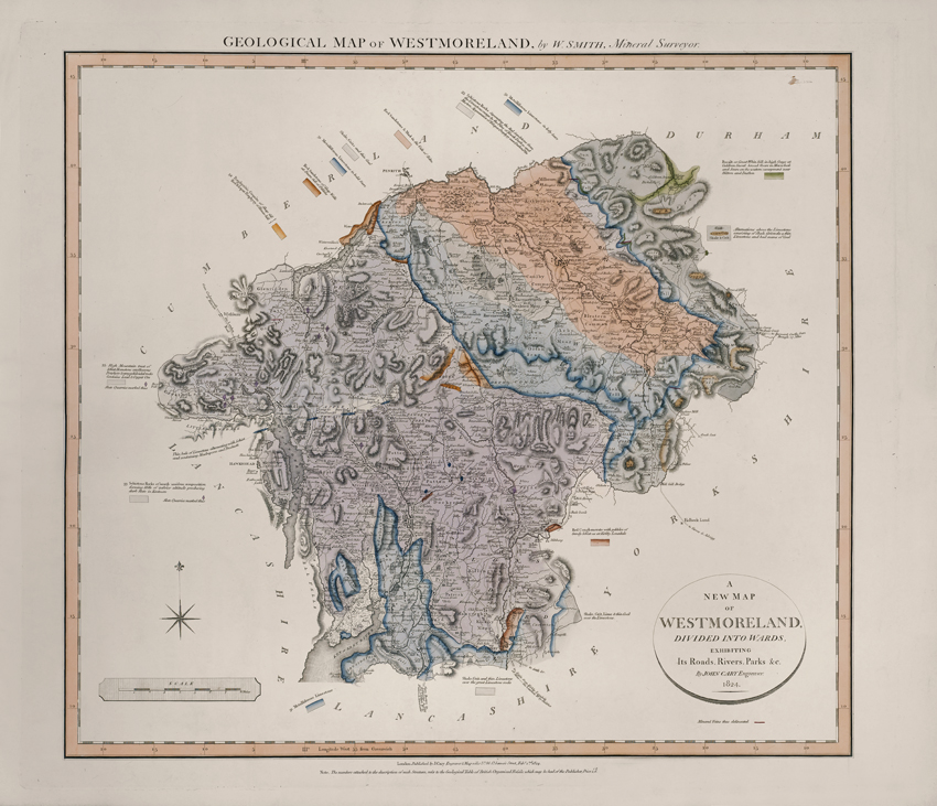
Title: Geological map of Westmoreland.

Creator: William Smith

Description: Geological map of the English county of Westmorland. This map was published in the sixth of William Smith’s series of six atlases of geological maps of English counties

Date: 1824

Format: Geological map

Image reference: 07-94

Original size: 62 x 53 cm.

Recommend print size: Up to 40 x 27 inches (100 x 70 cm.)

Geological Map of Suffolk (William Smith, 1819)

Title: Geological map of Suffolk.

Creator: William Smith

Description: Geological map of the English county of Suffolk. This map was published in the second of William Smith’s series of six atlases of geological maps of English counties

Date: 1819

Format: Geological map

Image reference: 07-93

Original size: 62 x 54 cm.

Recommend print size: Up to 40 x 27 inches (100 x 70 cm.)

Geological Map of Northumberland (William Smith, 1824)

Title: Geological map of Northumberland.

Creator: William Smith

Description: Geological map of the English county of Northumberland. This map was published in the sixth of William Smith’s series of six atlases of geological maps of English counties

Date: 1824

Format: Geological map

Image reference: 07-91

Original size: 62 x 54 cm.

Recommend print size: Up to 40 x 27 inches (100 x 70 cm.)

Geological Map of Nottinghamshire (William Smith, 1821)

Title: Geological map of Nottinghamshire.

Creator: William Smith

Description: Geological map of the English county of Nottinghamshire. This map was published in the fifth of William Smith’s series of six atlases of geological maps of English counties

Date: 1821

Format: Geological map

Image reference: 07-92

Original size: 61 x 51 cm.

Recommend print size: Up to 40 x 27 inches (100 x 70 cm.)

Geological Map of Huntingdonshire (William Smith, 1821)

Title: Geological map of Huntingdonshire.

Creator: William Smith

Description: Geological map of the English county of Huntingdonshire. This map was published in the fifth of William Smith’s series of six atlases of geological maps of English counties

Date: 1821

Format: Geological map

Image reference: 07-90

Original size: 61 x 52 cm.

Recommend print size: Up to 40 x 27 inches (100 x 70 cm.)

Geological Map of Essex (William Smith, 1820)

Title: Geological map of Essex.

Creator: William Smith

Description: Geological map of the English county of Essex. This map was published in the third of William Smith’s series of six atlases of geological maps of English counties

Date: 1820

Format: Geological map

Image reference: 07-89

Original size: 61 x 52 cm.

Recommend print size: Up to 40 x 27 inches (100 x 70 cm.)

Geological Map of Cumberland (William Smith, 1824)

Title: Geological map of Cumberland.

Creator: William Smith

Description: Geological map of the English county of Cumberland. This map was published in the sixth of William Smith’s series of six atlases of geological maps of English counties

Date: 1824

Format: Geological map

Image reference: 07-88

Original size: 52 x 62 cm.

Recommend print size: Up to 40 x 27 inches (100 x 70 cm.)

  • Small £2.50 + P+P
  • Medium £5.50 + P+P
  • Large + P+P