A new philosophico chorographical chart of East-Kent (Packe, 1743)

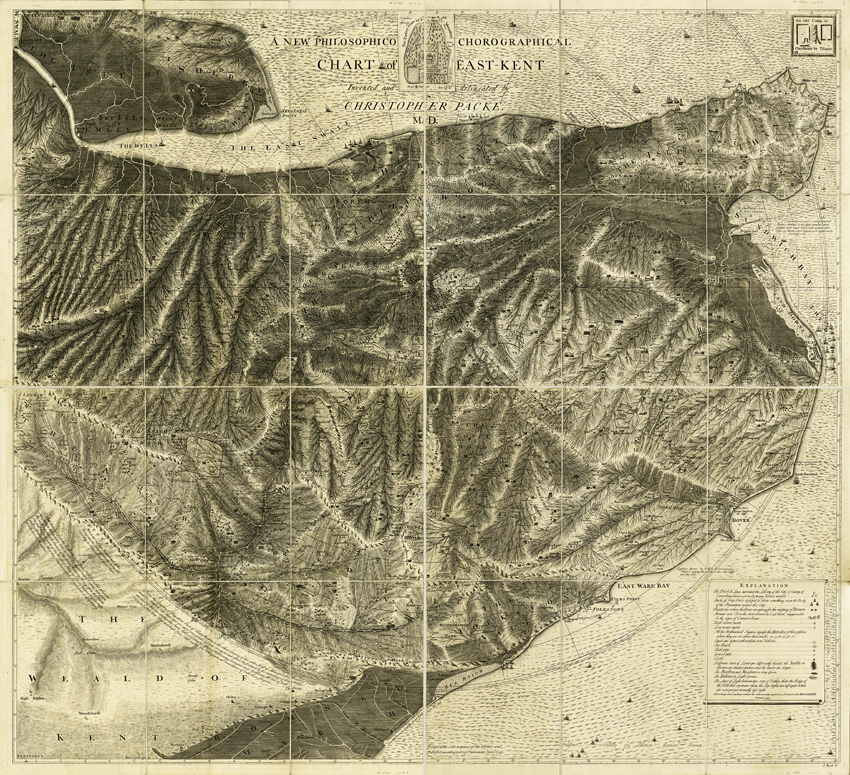
Title: A new philosophico chorographical chart of East-Kent

Creator: Christopher Packe [1686-1749]

Description: Engraved and lithographed print on paper, dissected and mounted on linen.  The original is in four separate sheets.  Co-ordinates are given as bearing and distance from Canterbury.  Map includes locations of chalk and gravel pits, shore and cliff line springs, and locations where amber and copperas stone have been found. Published according to Act of Parliament June 1st 1743.  The detailed line work on this map is very fine and needs to be printed as large as possible for best results.

Date: 1743

Format: Geological map

Image reference: 07-160

Original size: 137 x 125 cm.

Recommend print size: Up to 40 x 35 inches (100 x 90 cm.)

Map of the English Lakes (Ruthven, 1855)

Title: Map of the English Lakes and adjoining country geologically coloured

Creator: John Ruthven

Description: Hand-coloured geological map of the Lake District in north-west England

Date: 1855

Format: Geological map

Image reference: 07-99

Original size: 47 x 42 cm.

Recommend print size: Up to 27 x 20 inches (70 x 50 cm.)

Geological map of Cyprus (Bellamy, 1905)

Title: A geological map of Cyprus

Creator: Charles Vincent Bellamy

Description: At a scale of 5½  miles to the inch or 1:348480

Date: 1905

Format: Geological map

Image reference: 07-98

Original size: 46 x 62 cm.

Recommend print size: Up to 27 x 20 inches (70 x 50 cm.)

Geological map of the neighbourhood of Cambridge (Jukes-Browne, 1874)

Title: Geological map of the neighbourhood of Cambridge

Creator: Alfred John Jukes-Browne [1851-1914]

Description: Base on the one inch sheet 51SW and at a scale of one inch to the mile (1:63,360)

Date: 1874

Format: Geological map

Image reference: 07-97

Original size: 39 x 51 cm.

Recommend print size: Up to 27 x 20 inches (70 x 50 cm.)

Geological map of Scotland (Geikie, 1910)

Title: Geological map of Scotland

Creator: Sir Archibald Geikie [1835-1924]

Description: The new edition of the Geological Map of Scotland Geikie at a scale of 10 miles to the inch.

Date: 1910

Format: Geological map

Image reference: 07-96

Original size: 83 x 70 cm.

Recommend print size: Up to 40 x 27 inches (100 x 70 cm.)

Geological Map of Westmoreland (William Smith, 1824)

Title: Geological map of Westmoreland.

Creator: William Smith

Description: Geological map of the English county of Westmorland. This map was published in the sixth of William Smith’s series of six atlases of geological maps of English counties

Date: 1824

Format: Geological map

Image reference: 07-94

Original size: 62 x 53 cm.

Recommend print size: Up to 40 x 27 inches (100 x 70 cm.)

Geological Map of Suffolk (William Smith, 1819)

Title: Geological map of Suffolk.

Creator: William Smith

Description: Geological map of the English county of Suffolk. This map was published in the second of William Smith’s series of six atlases of geological maps of English counties

Date: 1819

Format: Geological map

Image reference: 07-93

Original size: 62 x 54 cm.

Recommend print size: Up to 40 x 27 inches (100 x 70 cm.)

Geological Map of Northumberland (William Smith, 1824)

Title: Geological map of Northumberland.

Creator: William Smith

Description: Geological map of the English county of Northumberland. This map was published in the sixth of William Smith’s series of six atlases of geological maps of English counties

Date: 1824

Format: Geological map

Image reference: 07-91

Original size: 62 x 54 cm.

Recommend print size: Up to 40 x 27 inches (100 x 70 cm.)

Geological Map of Nottinghamshire (William Smith, 1821)

Title: Geological map of Nottinghamshire.

Creator: William Smith

Description: Geological map of the English county of Nottinghamshire. This map was published in the fifth of William Smith’s series of six atlases of geological maps of English counties

Date: 1821

Format: Geological map

Image reference: 07-92

Original size: 61 x 51 cm.

Recommend print size: Up to 40 x 27 inches (100 x 70 cm.)

Geological Map of Huntingdonshire (William Smith, 1821)

Title: Geological map of Huntingdonshire.

Creator: William Smith

Description: Geological map of the English county of Huntingdonshire. This map was published in the fifth of William Smith’s series of six atlases of geological maps of English counties

Date: 1821

Format: Geological map

Image reference: 07-90

Original size: 61 x 52 cm.

Recommend print size: Up to 40 x 27 inches (100 x 70 cm.)

Geological Map of Essex (William Smith, 1820)

Title: Geological map of Essex.

Creator: William Smith

Description: Geological map of the English county of Essex. This map was published in the third of William Smith’s series of six atlases of geological maps of English counties

Date: 1820

Format: Geological map

Image reference: 07-89

Original size: 61 x 52 cm.

Recommend print size: Up to 40 x 27 inches (100 x 70 cm.)

Geological Map of Cumberland (William Smith, 1824)

Title: Geological map of Cumberland.

Creator: William Smith

Description: Geological map of the English county of Cumberland. This map was published in the sixth of William Smith’s series of six atlases of geological maps of English counties

Date: 1824

Format: Geological map

Image reference: 07-88

Original size: 52 x 62 cm.

Recommend print size: Up to 40 x 27 inches (100 x 70 cm.)

Geological Map of India (Geological Survey of India, 1891)

Title: Geological map of India, 2nd edition.

Creator: Geological Survey of India

Description: 2nd edition of the Geological Map of India at a scale of approximately 1:6,000,000

Date: 1891

Format: Geological map

Image reference: 07-87

Original size: 63 x 70 cm.

Recommend print size: Up to 40 x 27 inches (100 x 70 cm.)

Geological map of the United States (Hitchcock and Blake, 1872)

Title: Geological map of the United States compiled for the 9th census

Creator: Charles Henry Hitchcock [1836-1919] and William Phipps Blake [1826-1910]

Description: Geological map of the contiguous United States at a scale of 1:5,000,000

Date: 1872

Format: Geological map

Image reference: 07-86

Original size: 54 x 84 cm.

Recommend print size: Up to 40 x 27 inches (100 x 70 cm.)

Geological map of the environs of Lyme Reis – Cover (De La Beche, 1826)

Title: Geological map of the environs of Lyme Regis.

Creator: Henry T. De La Beche [1796-1855]

Description: The cover of  De La Beche’s guide to the geology of Lyme Regis at a scale of roughly 1 inch to the mile [1:63,360]

Date: 1826

Format: Geological map cover

Image reference: 07-85

Original size: 23 x 29 cm.

Recommend print size: Up to 16 x 12 inches (40 x 30 cm.)

Geological map of the environs of Lyme Reis (De La Beche, 1826)

Title: Geological map of the environs of Lyme Regis.

Creator: Henry T. De La Beche [1796-1855]

Description: A tourist guide to the geology of Lyme Regis at a scale of roughly 1 inch to the mile [1:63,360]

Date: 1826

Format: Geological map

Image reference: 07-84

Original size: 23 x 29 cm.

Recommend print size: Up to 16 x 12 inches (40 x 30 cm.)

  • Small £2.50 + P+P
  • Medium £5.50 + P+P
  • Large + P+P