Fingal’s Cave, Staffa

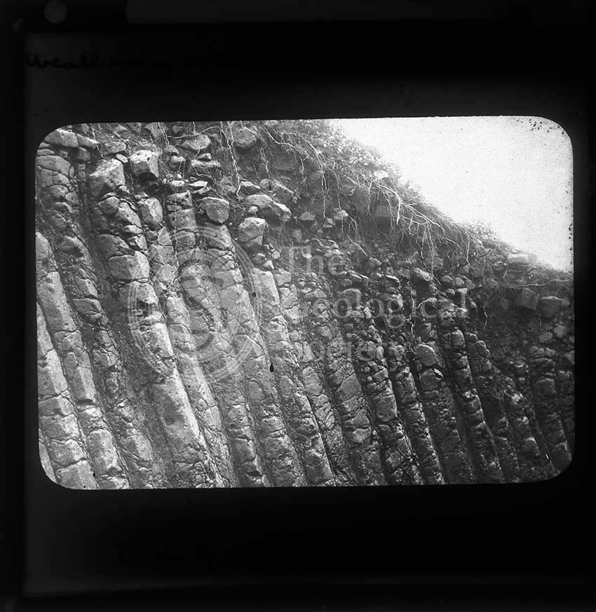
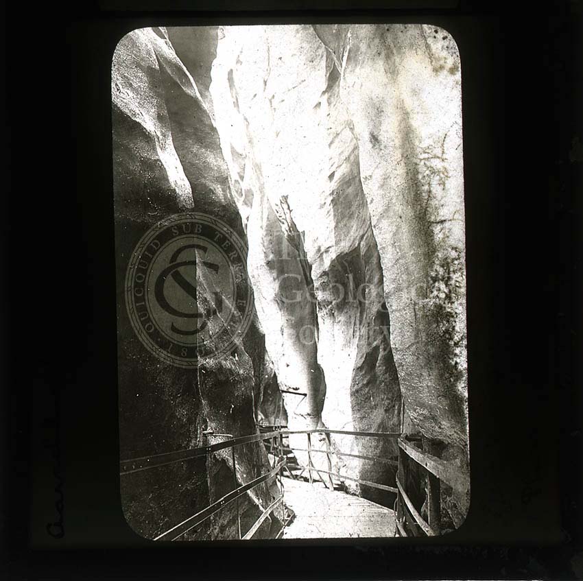
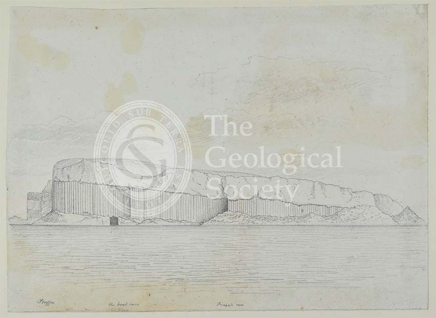
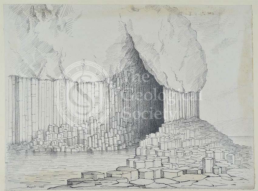
Title: Fingal’s Cave, Staffa, from an album of sketches by John MacCulloch

Creator: John MacCulloch

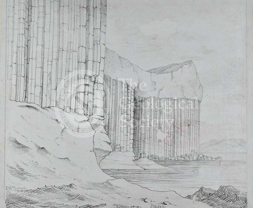
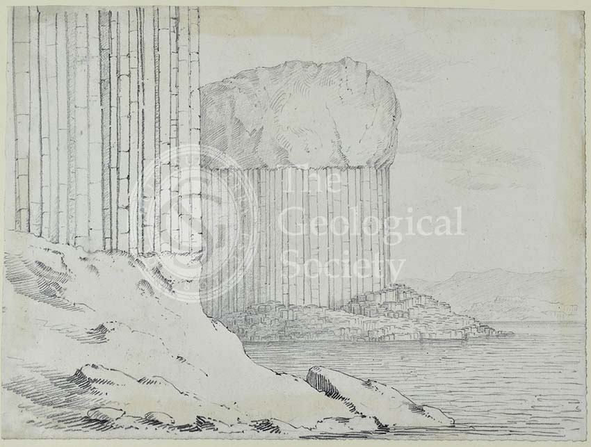
Description: Sketch of Fingal’s Cave, on the island of Staffa, in the Hebrides. It is a sea cave, but it is possible to reach it overland from another part of the uninhabited island. The whole island is formed of columnar basalt.

The sketch was drawn by John MacCulloch, a geologist who produced one of the first geological maps of Scotland. It may have been done while he was researching his Description of the Western Islands of Scotland, including the Isle of Man, (Edinburgh; London: Archibald Constable and Co.; Hurst, Robinson, and Co., 1819) and The Highlands and Western Isles of Scotland […], (London: Longman, Hurst, Rees, Orme, Brown, and Green, 1824).

Date: [c.1810s]

Format: Sketch

Archive reference: LDGSL/78/2/8

Image reference: 05-19

Recommended print size: Up to 16 x 12 inches (40 x 30cm)

Geological cross section of Otago, New Zealand (Hector, 1862-1864)

Title: Geological cross section of Otago, New Zealand

Creator: James Hector

Description: A geological cross section of the province, now region, of Otago, New Zealand.

This image was produced to accompany Hector’s paper ‘On the Geology of Otago’, read at the Geological Society on 7th December 1864. One section of the paper was subsequently published in Quarterly Journal of the Geological Society of London, vol.21 (1865), pp.123-128.

Date: [1862-1864]

Format: Sketch section

Archive reference: LDGSL/242

Image reference: 07-02

Recommended print size: Up to 20 x 16 inches (50 x 40cm)

Basalt, Asbach (Siebengebirge)

Title: Weathering of basalt, Asbach, Siebengebirge

Creator: Ananda Kentish Coomaraswamy

Description: Photo of weathered columnar basalt at Asbach, Germany, near the Siebengebirge range.

Date: [1890s-1900s]

Format: Black and white photographic lantern slide

Archive reference: LDGSL/1088/AC/EUR/34

Image reference: 05-14

Recommended print size: Up to 10 x 8 inches (25 x 14cm)

Fossil bivalves

Title: Fossil bivalves

Creator: C R Bone, printed by Hullmandel and Walton

Description: Illustrative plate showing various fossil bivalves.

Source: Forbes, Edward: “Report on the Fossil Invertebrata from Southern India, collected by Mr. Kaye and Mr. Cunliffe”, ‘Transactions of the Geological Society of London’, Series 2, Vol 7 (1845), pp97-174, plate XVII.

Format: Lithograph

Image reference: 04-39

Recommended print size: Up to 16 x 12 inches (40 x 30cm)

Map of Otago, New Zealand (Hector, 1862-1864)

Title: Geological sketch map of the province of Otago

Creator: James Hector

Description: A geological map of the province, now region, of Otago, New Zealand.

This image was produced to accompany Hector’s paper ‘On the Geology of Otago’, read at the Geological Society on 7th December 1864. One section of the paper was subsequently published in Quarterly Journal of the Geological Society of London, vol.21 (1865), pp.123-128.

Date: [1862-1864]

Format: Sketch map

Archive reference: LDGSL/242

Image reference: 07-01

Recommended print size: Up to 20 x 16 inches (50 x 40cm)

Junction of Gorner and Theodule glaciers

Title: Junction of Gorner and Theodule Glaciers

Creator: Ananda Kentish Coomaraswamy

Description: Photo of the meeting point of the Gorner and Theodul glaciers, Switzerland.

Date: [1890s-1900s]

Format: Black and white photographic lantern slide

Archive reference: LDGSL/1088/AC/EUR/50

Image reference: 05-18

Recommended print size: Up to 10 x 8 inches (25 x 14cm)

Fossil bivalves

Title: Fossil bivalves

Creator: C R Bone, printed by Hullmandel and Walton

Description: Illustrative plate of various fossil bivalves.

Source: Forbes, Edward: “Report on the Fossil Invertebrata from Southern India, collected by Mr. Kaye and Mr. Cunliffe”, ‘Transactions of the Geological Society of London’, Series 2, Vol 7 (1845), pp97-174, plate XVI.

Format: Lithograph

Image reference: 04-38

Recommended print size: Up to 16 x 12 inches (40 x 30cm)

Fossil mollusca

Title: Fossil mollusca

Creator: C R Bone, printed by Hullmandel and Walton

Description: Illustrative plate showing the structure of fossil mollusca.

Source: Forbes, Edward: “Report on the Fossil Invertebrata from Southern India, collected by Mr. Kaye and Mr. Cunliffe”, ‘Transactions of the Geological Society of London’, Series 2, Vol 7 (1845), pp97-174, plate XV.

Format: Lithograph

Image reference: 04-37

Recommended print size: Up to 16 x 12 inches (40 x 30cm)

Aar Gorge, Switzerland

Title: Aarschlucht. Meiringen

Creator: Ananda Kentish Coomaraswamy

Description: Photo of the Aar Gorge, Switzerland. The gorge through the limestone ridge was formed due to erosion by glacial meltwater at the end of the last ice age. The river Aar flows through the bottom of the narrow gorge. The public have been able to walk through the gorge via a series of paths, walkways and tunnels since 1888.

Date: [1890s-1900s]

Format: Black and white photographic lantern slide

Archive reference: LDGSL/1088/AC/EUR/45

Image reference: 05-17

Recommended print size: Up to 10 x 8 inches (25 x 14cm)

Geological Map of the British Isles (Teall, 1912)

Title: Geological Map of the British Islands based on the work of the Geological Survey

Creator: Jethro Justinian Harris Teall

Description: Geological map of the British Isles, at a scale of 1:1,584,000.

Publisher: Ordnance Survey

Date: 1912

Format: Geological map

Image reference: 07-09

Size of original: 80 cm. x 58 cm.

Recommended print size: up to 100 cm x 70 cm.

Nautilus and bivalves

Title: Nautilus lineatus, Cornbrash, Bromham, rock & two other bivalves

Creator: Richard Cowling Taylor (1789-1851)

Description: Studies of a fossil Nautilus lineatus found in Cornbrash, Bromham, & two other bivalves. The drawings have been annotated by George Bellas Greenough, probably cross referencing the fossils with those which appear in James Sowerby’s publication ‘Mineral Conchology’ (1812-1829).

Date: [c.1810s-1820s]

Format: Watercolour on paper

Archive reference: LDGSL/573-7

Image reference: 04-45

Recommended print size: Up to 70 x 50cm

Giant’s Causeway

Title: Giant’s Causeway, Northern Ireland

Creator: Giacomo Leonardis, after a painting by Antonio de Bittio

Description: Engraving of the Giant’s Causeway, an area of columnar basalt on the coast of Northern Ireland. Its name comes from the legend that it was built by the Irish giant Finn MacCool (Fionn mac Cumhaill) across to Scotland to fight a Scottish giant.

This image was originally published in A series of plates representing the most extraordinary and interesting basaltic mountains, caverns and causeways in the known world. Fifty engravings (London: John Manson, 1825).

Date: 1807

Format: Black and white engraving

Archive reference: LDGSL/1105 no.1

Image reference: 05-23

Recommended print size: Up to 16 x 12 inches (40 x 30cm)

Geological Map of Connemara, Ireland (Nimmo, c.1813)

Title: Geological map of Connemara, Ireland

Creator: Alexander Nimmo

Description: Hand-coloured geological map of Connemara, Ireland. Connemara is an area in the west of the country, in the west part of County Galway.

Clifton Village, which appears on the map was founded c.1812.  George Bellas Greenough whose writing appears on the map, visited the area with Alexander Nimmo in 1813.

Date: [c.1813]

Format: Manuscript, backed on cloth

Archive reference: LDGSL/947/6/F/2

Image reference: 07-08

Recommended print size: Up to 20 x 16 inches (50 x 40cm)

Assemblage of fossil bivalves, gastropods and ammonites

Title: Assemblage of fossil bivalves, gastropods and ammonites

Creator: Richard Cowling Taylor (1789-1851)

Description: Study of an assemblage of various fossil bivalves, gastropods and ammonites, including Avicula echinata and Avicula media.

Date: [c.1810s-1820s]

Format: Watercolour on paper

Archive reference: LDGSL/573-5

Image reference: 04-44

Recommended print size: Up to 16 x 12 inches (40 x 30cm)

Section of England: Chesterfield to Bolsover (Greenough, 1810)

Title: Chesterfield to Bolsover, from John Farey’s four horizontal sections of England

Creator: George Bellas Greenough (from a drawing by John Farey)

Description: Drawing of a geological cross section across England, from Wigley, Derbyshire, to the county boundary with Nottinghamshire, passing through the settlements of Chesterfield and Bolsover.

This drawing was presented to the Geological Society by Greenough on 2nd November 1810.

Date: c.1810

Format: Coloured drawing

Archive reference: LDGSL/450

Image reference: 07-07

Recommended print size: Up to 70 x 50cm

Staffa, showing Fingal’s Cave

Title: Staffa, showing Fingal’s Cave, from an album of sketches by John MacCulloch

Creator: John MacCulloch

Description: Sketch of the island of Staffa, in the Hebrides, with Fingal’s Cave visible. It is a sea cave, but it is possible to reach it overland from another part of the uninhabited island. The whole island is formed of columnar basalt and is a popular visitor attraction.

The sketch was drawn by John MacCulloch, a geologist who produced one of the first geological maps of Scotland. It may have been done while he was researching his Description of the Western Islands of Scotland, including the Isle of Man, (Edinburgh; London: Archibald Constable and Co.; Hurst, Robinson, and Co., 1819) and The Highlands and Western Isles of Scotland […], (London: Longman, Hurst, Rees, Orme, Brown, and Green, 1824).

Date: [c.1810s]

Format: Sketch

Archive reference: LDGSL/78/2/8

Image reference: 05-22

Recommended print size: Up to 16 x 12 inches (40 x 30cm)

Study of an ammonite

Title: Study of an ammonite

Creator: Richard Cowling Taylor (1789-1851)

Description: Study of an unnamed species of ammonite.

Date: [1810s-1820s]

Format: Watercolour on paper

Archive reference: LDGSL/573-2

Image reference: 04-43

Recommended print size: Up to 16 x 12 inches (40 x 30cm)

Section of England: Petersfield to the Isle of Wight (Greenough, 1812)

Title: Petersfield to the Isle of Wight, from John Farey’s four horizontal sections of England

Creator: George Bellas Greenough (from a drawing by John Farey)

Description: Drawing of a geological cross section across England, from Petersfield, Hampshire, to the south of the Isle of Wight. [32cm x 15.8cm]

Date: 1812

Format: Coloured drawing

Archive reference: LDGSL/450

Image reference: 07-06

Recommended print size: Up to 70 x 50cm

Staffa in profile

Title: Staffa in profile, from an album of sketches by John MacCulloch

Creator: John MacCulloch

Description: Sketch of the island of Staffa, in the Hebrides. The whole island is formed of columnar basalt, with several caves around its coastline, and is a popular visitor attraction. Two caves can be seen in the image above – Boat Cave, the black hole to the left of the picture, and Fingal’s Cave, the large crevice in the centre.

The sketch was drawn by John MacCulloch, a geologist who produced one of the first geological maps of Scotland. It may have been done while he was researching his Description of the Western Islands of Scotland, including the Isle of Man, (Edinburgh; London: Archibald Constable and Co.; Hurst, Robinson, and Co., 1819) and The Highlands and Western Isles of Scotland […], (London: Longman, Hurst, Rees, Orme, Brown, and Green, 1824).

Date: [c.1810s]

Format: Sketch

Archive reference: LDGSL/78/2/8

Image reference: 05-21

Recommended print size: Up to 16 x 12 inches (40 x 30cm)

Geological cross sections of Jamaica (Wall, 1864)

Title: Geological cross sections of Jamaica

Creator: George Parkes Wall

Description: Several geological cross sections of Jamaica.

This image was produced to accompany a paper read before the Geological Society on 9th November 1864 and published as PM Duncan and GP Wall, ‘A Notice of the Geology of Jamaica, especially with reference to the District of Clarendon; with Descriptions of the Cretaceous, Eocene, and Miocene Corals of the Islands’, Quarterly Journal of the Geological Society, vol.21 (1865), pp.1-14.

Date: [1864]

Format: Sketch section

Archive reference: LDGSL/239

Image reference: 07-05

Recommended print size: Up to 70 x 50cm

Madrepore from the white chalk, Hunstanton Cliff

Title: Madrepore, from the white chalk, Hunstanton Cliff.

Creator: Richard Cowling Taylor (1789-1851)

Description: Madrepore [a type of fossil coral], from the white chalk, Hunstanton Cliff.

Date: [c.1810s]

Format: Watercolour on paper

Archive reference: LDGSL/573-1

Image reference: 04-42

Recommended print size: Up to 20 x 16 inches (50 x 40cm)

Staffa

Title: Staffa, from an album of sketches by John MacCulloch

Creator: John MacCulloch

Description: Sketch of part of the island of Staffa, in the Hebrides. The whole island is formed of columnar basalt, with several caves around its coastline, and is a popular visitor attraction.

The sketch was drawn by John MacCulloch, a geologist who produced one of the first geological maps of Scotland. It may have been done while he was researching his Description of the Western Islands of Scotland, including the Isle of Man, (Edinburgh; London: Archibald Constable and Co.; Hurst, Robinson, and Co., 1819) and The Highlands and Western Isles of Scotland […], (London: Longman, Hurst, Rees, Orme, Brown, and Green, 1824).

Date: [c.1810s]

Format: Sketch

Archive reference: LDGSL/78/2/8

Image reference: 05-20

Recommended print size: Up to 16 x 12 inches (40 x 30cm)

Map of Jamaica (Wall, 1864)

Title: Map indicating the proximate distribution of the geological formations of Jamaica

Creator: George Parkes Wall

Description: A geological map of Jamaica.

This map was produced to accompany a paper read before the Geological Society on 9th November 1864 and published as PM Duncan and GP Wall, ‘A Notice of the Geology of Jamaica, especially with reference to the District of Clarendon; with Descriptions of the Cretaceous, Eocene, and Miocene Corals of the Islands’, Quarterly Journal of the Geological Society, vol.21 (1865), pp.1-14.

Date: [1864]

Format: Sketch map

Archive reference: LDGSL/239

Image reference: 07-04

Recommended print size: Up to 20 x 16 inches (50 x 40cm)

  • Small £2.50 + P+P
  • Medium £5.50 + P+P
  • Large + P+P